Якщо ви добре орієнтуєтеся в географії, значить вам не важко буде легко описати стан Великобританії на мапі англійською мовою. А якщо ні, то ви завжди можете скористатися нашим топиком, який проведе вас по країні від півдня до півночі, і з сходу на захід.
Вивчаючи карту Англії англійською, єдине, що доведеться зробити - це запам'ятати багато назв. Моря, гори, міста, столиці і річки можуть викликати утруднення. Але не переживайте, ви зможете! У нашій статті ви знайдете найбільш значущі об'єкти.
Отже, найкраще, коли ви почнете читати наш топік, подивіться як виглядає карта Великобританії англійською мовою. І прочитавши кожне речення, знайдіть, про що йде мова. Так ви швидше запам'ятаєте всю інформацію.
Look at the map. You can see that the United Kingdom of Great Britain and Northern Ireland is situated on1 the Isles2 . They are called the British Isles3 There are more than 5000 small islands there. Two of them are the biggest: Great Britain and Ireland. We know that the UK consists of 4 countries: England, Wales, Scotland and Northern Ireland. England, Scotland and Northern Ireland are situated on the largest island which is called Great Britain. Northern Ireland is situated on the smaller one which is called Ireland and occupies the northern part of it.
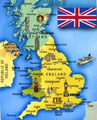
You can see that the UK is washed by water 4 from all sides. It is separated from5 Europe by the English Channel and the Strait of Dover . It is washed by the Atlantic ocean in the west , by the North sea in the east. The UK is separated from the Ireland by the Irish sea . The geographical position flavoured the development of the country as a great sea country.
England occupies6 the southern part of Great Britain. Scotland is in the north of the island and Wales is in the west of Great Britain and Northern Ireland is in the north-east of Ireland.
The central and the most beautiful part of the county is England. The landscape is diverse7. In the north and in the west of the country you can see mountains8 , but the other area is plain9. England has more fertile soil10 than others. Also there are many lakes in the north-western district11 which is known as Lake District.
Scotland can be called the country of mountains. The region of the mountains which is known as Highlands is the oldest in the world . The Grampians is the chain12 of the mountains there . Ben Nevis is the highest peak13. There are some other chains: the Pennine in England and the Cumbrian Mountains in Wales .
You will find a lot of forests along the county. But none of them can be called great. The biggest one is Sherwood Forest. It occupies the area in the eastern part of England. Of course, you have heard the legends about it. The most famous is about Robin Hood.
There are many rivers in the UK. But they are not long. The longest one is the Severn which flows in England . The Thames, the Mersey and the Clyde are the most important rivers . They play a great role in British trade and commerce.You can travel by water along the whole country because many of the rivers are connected14 by canals .
London, Glasgow, Liverpool, Birmingham, Manchester and Edinburgh are the largeast cities in the UK . The total area15 of the UK is 224,000 sq km. And the population16 is about 60 million. Its advantageous17 position has made the UK one of the powerful country in the world .
Vocabulary:
- to be situated on - знаходиться на
- the Isles - острова
- the British Isles - Британські острови
- to be washed by water - омивається водою
- to be separated from - відділяється від
- occupy - займає
- diverse - різноманітний
- mountains - гори
- plain - рівнинна
- fertile soil - родючий грунт
- district - район
- chain - гірські ланцюги
- peak - вершина гори
- to be connected - з'єднані
- total area - загальна територія
- population - населення
- advantageous - вигідне становище
Great Britain and Ireland - острова Великобританія і Ірландія
England, Wales, Scotland and Northern Ireland - Англія, Уельс, Шотландія, Північна Ірландія
the English Channel and the Strait of Dover - Ла-Манш і Ла-де-Кале (Дуврська протока)
the Atlantic ocean, the Irish sea - Атлантичний океан, Ірландське море
Highlands - Хайлендс (гориста місцевість)
Ben Nevis - Бен Невіс
The Grampians, the Pennine, the Cumbrian Mountains in Wales - Грампианские гори, Пеннинские гори, Камбріанскіе гори
The Thames, the Mersey and the Clyde, the Severn - Темза, Мерсі (Мерсі), Клайд, Северн
London, Glasgow, Liverpool, Birmingham, Manchester and Edinburgh - Лондон, Глазго, Ліверпуль, Бірмінгем, Манчестер, Единбург
Ну що, прочитали? Перевели? Осмислили? Карта Англії англійською буде виглядати не так лякає, якщо ви переглянете і проаналізуєте текст ще раз. Спробуйте назвати тільки річки, де вони і які. Столиці, гори, ніж відділяється і де знаходяться. Вчити по частинах буде легше. Дерзайте!
Перевели?Осмислили?
